Wednesday, November 20, 2013

Cartograms

http://www.dailykos.com/story/2009/01/07/680694/-Breaking-wind-e-mail-this-year-last-year-and-in-2000#
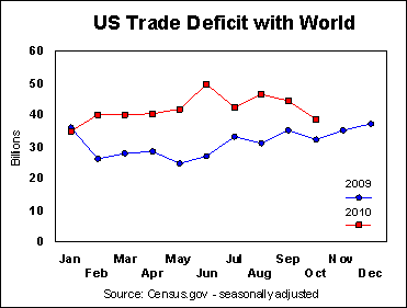
Cartograms are maps that use distortion of areas to convey the information. The cartogram above shows a map of the 2008 Electoral Vote in the election that shows Obama (blue) overwhelming McCain (red). To me, this is an easy way to portray the dominance of one aspect compared to another.

Bilateral Graph

http://seekingalpha.com/article/241440-will-octobers-improved-trade-deficit-continue
A bilateral graph is a graph that represents more than one variable and can be portrayed in many different ways. The map above shows the different trade deficit that the US had in 2009 vs. 2010.

Statistical Maps

http://www3.uakron.edu/src/DataServ/Abstract/
Statistical maps are maps that shows the results on a map after the results are in of a test or survey. The map above shows the percent of workers who carpooled in 2003.

Range Graded Proportional Circle Map

http://www.e-cartouche.ch/content_reg/cartouche/cartdesign/en/html/ThemMaps_ThemData.html
A range graded proportional circle map are maps that use a set amount of circles and that have a range of values for each circle within the legend. This avoids overcrowding. The map above portrays the amount of inhabitants in the communities of Zurich.

Continuously Variable Proportional Circle Map

http://geographyfieldwork.com/DataPresentationMappingTechniques.htm
A continuously variable proportional circle map is a map that shows us how different variables can be expressed in appropriate matters while still retaining its' proportionality. The map above shows this by the bigger circles representing a larger population of people.

Correlation Matrix

http://yin.che.wisc.edu/images.htm
A correlation matrix is a matrix that conveys the correlation between all pairs of data sets. A correlation matrix simply compares two things and establishes what relationship they have with one another. The matrix above shows what a phage T7 is and how they range from high, or red, to low, or blue.

Similarity Matrix

http://www.fxpal.com/?p=eventDetector
Similarity matrix is a matrix of scores that represent the similarities between points. As shown above, this similarity matrix shows the matrix of a combination of 512 photos.

Cartographic Animations

http://rsd.gsfc.nasa.gov/rsd/images/andrew.html

Cartographic animation is a visual that evolves in the changes of display. These animations can portray how a hurricane loses power as it makes landfall, like shown above.

LIDAR

http://www.lidarbasemaps.org/

LIDAR is an acronym that stands for light detection and ranging. LIDAR is an optical sensing technology that measures the distance to and from properties by targeting the area with light, or a laser.

Flow Map

http://www.mynetbizz.com/pages/airlines/america-west-airlines/america-west-airlines.cfm
Flow maps are a mixture of flow charts and maps. These maps are designed to show the flow of people and goods. This is beneficial for mapping the transferring of goods. The image above is a flow map of airline flights of American West Flights. Phoenix and Las Vegas are some of the major hubs on the west coast for this airline.

Proportional Circle Map

http://personal.frostburg.edu/sbriggs0/maps.htm
Proportional circle maps are used to show how much a single variable varies in the mapped area. Smaller circles usually represent areas of lower density and larger circles represent higher density. The map above shows the proportions that have more Wal-marts in the United States in 2009.

Dot Distribution Map

http://www.birds.cornell.edu/pfw_fr/Members/ParticipantMap00.htm
Dot distribution maps are an easy way to portray a variable that is being plotted. The clustering of dots shows an area of high density as an area with scattered points have low density. The map above portrays the number of people that participated in the FeederWatch Program for 2000-2001.

Doppler Radar

http://www.weather.com/maps/maptype/currentweatherusnational/usdopplerradar_large.html
Doppler radars are radars that give a doppler effect by producing velocity data about objects at a distance. The radar sends microwaves toward a desired object and listens to the reflection. They are commonly used by meteorologists. The map above shows the national Doppler radar of November 20, at 4:49 P.M.

Black and White Aerial Photo

http://www.colorado.edu/geography/gcraft/notes/remote/remote_f.html

Black and white aerial photos have been used to make the maps easier to read with because of the lack of color. The photo above is a black and white aerial photo of Austin, Texas. 

Infrared Aerial Photo

http://www.aerialarchives.com/Aerial-Maps-of-Sonoma-County.htm
Infrared aerial photos are pictures that can be used to distinguish environmental changes as well as the health of forests, wetlands, and other landscapes. The photo above is an aerial map of Sonoma County, California.

Isolines

http://www.kidsgeo.com/geography-for-kids/0034-isolines.php
Isoline maps are maps that have continuous lines joining points with the same value. Isolines can be used to interpret meaning of a thematic map. Color or pattern are used to describe distributions on a map. The map above is a simple weather report that shows the forecast of wind for the day.

Propaganda Map

http://historum.com/general-history/9905-propaganda-maps.html

Propaganda maps are maps that display images that are false, but are used for advertising. The map above is about everybody in Europe trying to bring down the dominance of the United States, which in this case is represented by the eagle.

Isohyets

http://www.info.bw/~mettest/bulletins/data/bulletin_0210/bulletin_0210.html
Isohyets are maps that use contour lines to link up areas that have equal amounts of rainfall during a certain amount of time. The map above shows the rainfall between 3 regions with region 2 varying the most.

Isopleth

http://www.aegis.jsu.edu/mhill/phygeogone/isoplth.html
Isopleth maps are common for mapping surface elevations, precipitation, atmospheric pressure and many other things that can be viewed as a third dimension. The maps above show examples of what an isopleth map can represent.

DOQQ

http://www.geomart.com/products/geodata/doqq/index.htm
Digital orthophotos quadrangles (DOQQ) are computer images of an aerial picture that have been removed of any large displacements. The image above is a natural and colored picture taken by the USGS.

DEM

http://www.sciencegl.com/gis_dem/index.html
Digital Evaluation Models are images that show differences in elevation which can be used to create models and representations. The DEM above is an image that shows the 3D graphics and multi-layer map that uses these transparencies to point out important characteristics.

DRG

http://www.tceq.texas.gov/gis/drg.html
Digital Raster Graphs (DRGs) are scanned images of a USGS topographic map and represents all of the georeferenced images on the surface of the earth. The map above shows a DRG of a Colorado town.

Isobar

http://www.sercc.com/education_files/saer_ans.html
Isobars use contour lines to connect points of equal atmospheric pressure from lines that are generated from sea level pressure. These maps are always changing and available due to the fact that atmospheric pressure is always changing. The map above shows the isobars in the United States on May 4, 2000.

DLG

http://tahoe.usgs.gov/DLG.html
Digital line graphs (DLG) are a collection of cartographic features that are depicted through vectors. This can eliminate the amount of paper maps we need. The map above is a DLG of Lake Tahoe with the red lines representing roads, green being vegetation, and blue being bodies of water.

Unclassed Choropleth Map

http://softwaresanta.com/sssmf/index.php?topic=2976.0
Unclassed choropleth maps use continuous shading and color schemes to correlate the data.

Bivariate Choropleth Map

http://www.geog.le.ac.uk/russianheartland/DemographicMaps/Raions.html
Bivariate choropleth maps show two different data sets and variables when dealing with a certain issue. The different colors represent the different time periods when they measured the population in Russia for this example.

Univariate Choropleth Map

http://www.cdc.gov/pcd/issues/2007/oct/07_0091.htm
A univariate choropleth map displays one variable throughout the map. The different shades represent the difference in that variable. This map shows the percentage of individuals living in poverty.

Star Plot


Star plots are useful because they give us a way to view a wide variety of data. The data starts in the center and will move out depending on the data presented. The star plot above shows an analysis of automobiles in 1979.

Accumulative Line Graph or Lorenz Curve

http://ingrimayne.com/econ/AllocatingRationing/MeasuringIncomeDist.html
An accumulative line graph, or Lorenz Curve, shows how a situation would be if there was equality and then show a line of the actual situation. These graphs are typically used in economics.

Index Value Plot

http://waterwatch.usgs.gov/new/?m=real&w=plot&r=nm
This is an example of an index value plot. This shows the stream flow in New Mexico over 45 days and can be used to see what patterns come up when looking at stream flow.

Standardized Choropleth Map

http://www.statcan.gc.ca/pub/92f0138m/2008003/figures/5200001-eng.htm
Standardized choropleth maps are used to show the distribution among an area and showing difference in that area. The map above shows the population percentage of Canada that is under 14 years old and younger, with the darker shade meaning the higher population.

Unstandardized Choropleth Map

http://eps.mq.edu.au/courses/GEOS219/choropleth.htm
Unstandardized choropleth maps are maps that use raw numbers and show the total value. The map above shows fertility rate from 2000-2005 with darker shaded areas having a higher rate of fertility.

Nominal Area Choropleth Map

http://politicalmaps.org/
Nominal area choropleth maps are maps that show nominal value measured in amounts, but not actual value. The picture above shows the results of the 2012 Presidential election between Obama and Romney with blue representing Obama's victory of the red of Romney.

Scatter Plot

http://www.netmba.com/statistics/plot/scatter/
Scatter plots are two-dimensional graphs that show the relationship between two variables by using data points. The graph above is an example of what a common scatter plot looks like. These are useful when dealing with a large amount of data.

Parallel Coordinate Graph

http://www.evl.uic.edu/aej/424/kyoung/Training-parallelcoordinate.html
Parallel coordinate graphs are used to analyze multivariate data and a way to view high dimensional geometry. This post coordinate graph shows the low number of density and UNEMP.

Mental Maps

http://www.fedstats.gov/kids/mapstats/concepts_mentalmaps.html
Mental maps are a person's visualization of what a place looks like on their sense of direction in the area. The map above is a drawing of the Nottingham City Centre in 1997 in the sense of the artist's eyes. They are simple to create as well as to read.

Windrose

http://www.wcc.nrcs.usda.gov/climate/windrose.html
Windrose plots show how wind speed and direction are distributed in a certain area. The wind rose above is a portrayal of the wind in Fresno, California in the month of April. This shows that most of the wind comes from the northwest of Fresno.

Climograph

http://www.cotf.edu/ete/modules/msese/earthsysflr/climograph.html
A climograph is a graphical representation of climate that portrays the monthly average temperature and precipitation and is useful to get a quick look at a climate of a location. For this climograph, the climate of Moose Factory, Canada is shown above.


Population Profile


http://www.hamptonroadsperforms.org/profiles/regional/profile.php
Population profiles are graphs that show the extent that a group of people exhibit a certain characteristic. This graph shows the distribution of age and sex that use the roads to transport around Hampton, Virginia in 2007.

Triangle Plot

http://www.pazsoftware.com/Ternary5.html
Triangle plots are also called ternary plots. These maps are a plot on three variables that equal a constant. They depict the ratios of the three variables in an equilateral triangle. The triangle plot above demonstrates the three variables to equal a constant.

Histogram

http://www.icoachmath.com/math_dictionary/histogram.html
Histograms are a graphical distribution of certain data. They are different than bar graphs because of the lack of spaces in between bars that histograms have. These histograms show the different discounts offered by super markets.

Box Plot

http://www.lohninger.com/boxplot.html

This map type is called a box plot. A box plot graphs data numerically by using the smallest observation, followed by 3 separate quartiles, and ends with the largest observation. The spacing between the boxes can depending on the difference in the data.

Stem and Leaf Plot

http://www.eduplace.com/math/mhm/5/06a/index.html

This map is a stem and leaf plot. The purpose of a stem and leaf plot is to display statistics and give the reader an easy and quick way to show the data by way of a graph. The stem is the left column and is only listed once, as the leaf could be repeated depending on the information provided.

Classed Choropleth Map

http://my.ilstu.edu/~jrcarter/Geo204/Choro/
This map is an example of a classed choropleth map. A classed choropleth map is a type of choropleth map where areal units are grouped into categories and are all assigned a color within the category. This map conveys males per 100 females in the United States in 2000.

PLSS Map

http://geology.isu.edu/geostac/Field_Exercise/topomaps/plss.htm
This map is an example of a Public Land Survey System, or PLSS. A PLSS map is a map that is used to locate areas, not points. Also, it does not use exact measurements. This isn't necessarily a good thing because accuracy is not at a high, but this is good for a quick, concise measurement of an area.


Cadastral Map


This map is an example of a cadastral map. This map shows the distribution of property in a city in Belgium. It is considered a cadastral map because the boundaries and shading represent who owns certain property.  

Thematic Maps

http://www4.uwsp.edu/geo/faculty/ritter/geog101/textbook/essentials/map_types.html

Thematic Maps are maps that are made to show a certain theme or pattern in each map. This map conveys a drought severity index and the different colors represent the different amount of drought in the area. It qualifies as a thematic map because there is a pattern in the map that shows droughts are happen more in the southern part of the United States.

Choropleth Map

http://www.cdc.gov/dhdsp/maps/national_maps/hd_all.htm
The map shown above is a Choropleth Map. These maps are an example of a thematic map which shows different shades in different areas to show statistical value within the map. This map portrays Heart Disease death rates in adults 35 and older from 2000-2006.

Topographic Map


http://www.acsu.buffalo.edu/~dbertuca/maps/cat/map-portion-images.html

This map is a Topographic Map of Crater Lake. In this map, contour lines and spot heights show relief. Also, isolines and soundings portray the depth of Crater Lake. The

Planimetric Map

http://www.webpages.uidaho.edu/niatt_labmanual/Chapters/roadwaydesign/theoryandconcepts/SurveysAndMaps.htm
The map type being shown here is a Planimetric Map. This map is conveying what features of land, man made or natural, are on this part of Buckthorn Drive without showing any elevation. These maps are taken from aerial photography.